Weather and Uncrewed Aircraft Systems (UAS)
How NCAR is Tackling This Challenge

As far as the potential drones have, the sky’s the limit. Well, up to 400 feet, that is.
Industry, government agencies, national security entities and recreational drone enthusiasts see how the growing uses of Uncrewed Aircraft Systems (UAS), commonly called drones, will contribute to our way of life. They’re far-ranging, from such life-saving applications as spotting a stranded hiker or hunter in the wilderness, to locating wildfire embers, to commercial innovations such as delivering package goods. It’s a burgeoning field with endless opportunities.
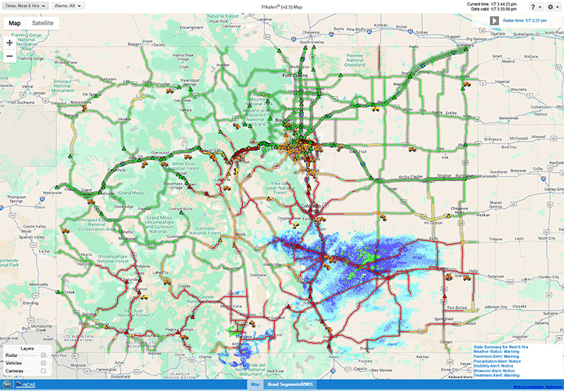
Yet these light-weight aircraft face their own unique challenges: low-altitude wind and weather. A seemingly benign five-knot headwind, for example, can mean disaster for a drone’s takeoff and flight path, possibly careening into the ground, or another aircraft or building. Forecasting such low-level weather is essential to the success of this emerging technology and is critical to UAS “traffic management,” in the parlance of users.
The National Aeronautics and Space Administration (NASA) and the Federal Aviation Administration (FAA) recognized that it is time to put in place a UAS traffic management (UTM) system for low-altitude. These agencies have had a long, symbiotic relationship in aviation; NASA supports research and development of prototypes, which then are migrated to the FAA for operational use. NCAR has a decades-long, proven track-record in aviation weather R&D with both agencies, and is in a unique position to leverage its capabilities to address these new challenges.
Last year, NASA’s Ames Research Center invited government, industry and academic partners to collaborate with NASA to identify research needs and to accelerate the development of a traffic management system. In July, NCAR and NASA conducted a workshop that addressed the advances in aviation weather research, the opportunities and weather constraints, such as ceiling visibility, lightening, convection, icing, precipitation and winds to UAS. Atmospheric turbulence rose to the top of users’ priorities.
NCAR was selected by NASA as one of the suppliers of weather information, including low-level turbulence, to support UAS traffic management regulated by the FAA. The low-level turbulence work has two foci:
- To provide low-level turbulence forecasts of turbulence, and
- To investigate the effect of this atmospheric turbulence on the UAS response (pitch, roll, trajectory changes).
The National Weather Service’s Aviation Center, the country’s hub of operational forecasts and advisories for airlines, has been using the Graphical Turbulence Product (GTG-3), an automated turbulence nowcast system used worldwide. This was developed by NCAR scientists and engineers and was designed to forecast turbulence for high- and mid-level flights (defined as above and below 18,000 feet). It is a fully automated system providing turbulence analyses and forecasts for the aviation community over the contiguous U.S., parts of Mexico and Canada, and the western Atlantic Ocean and eastern Pacific Ocean. The system automatically pulls full resolution native numerical weather prediction (NWP) model forecast grids as they become available, then computes an ensemble of turbulence diagnostics on a grid point by grid point basis, combines them, and finally interpolates the combination onto flight levels. Since its development in 2003, the GTG product has gone through a continuous cycle of upgrades, and each major upgrade is independently evaluated before being made available on the Aviation Weather Center’s web site.
Since 2015, NCAR has been working on modifying the GTG-3 to the lowest altitudes. This involves focusing on weather under 400 feet, for aircraft under 55 pounds, and for keeping the aircraft within its “geofence” (within proscribed boundaries and within the operator’s line of sight). This is a new and challenging undertaking for the research community, but one NCAR is poised to accomplish with its decades of aviation weather successes.
While this work is still relatively new, the NASA/NCAR workshop on integrating weather in UAS traffic management is a critical step in serving the FAA’s regulatory and operational requirements.
One important outcome from the workshop is the need for a UAS weather users’ group. All stakeholders should have a say in their needs and the direction of UAS traffic management. If you are interested in participating in this group, please contact Larry Cornman.