WRF-Hydro® Modeling System

The WRF-Hydro® Project develops leading edge hydrometeorological and hydrologic models and modeling support tools to investigate critical water issues around the globe. As an open platform, we strive to build and support a diverse and inclusive community of hydrologic scientists and practitioners to meet worldwide needs for water resource planning, hazard prediction and mitigation.
Water itself is boundless; so should be the community that studies it.
WRF-Hydro®, an open-source community model, is used for a range of projects, including flash flood prediction, regional hydroclimate impacts assessment, seasonal forecasting of water resources, and land-atmosphere coupling studies.
The underlying goal of WRF-Hydro® development is to improve prediction skill of hydrometeorological forecasts using science-based numerical prediction tools.
Colorado Flood of 11-15 Sept. 2013
WRF-Hydro model output: Accumulated Precipitation (shaded colors), 100m gridded streamflow (points)
Motivation
Scientists and society need a way to understand and predict how the complex components of the water cycle interact with the complexities of the landscape in order to provide data and information to address issues relating to water availability, water quality, hazards and impacts both in the short term and long term and across scales.
The Weather Research and Forecasting Model Hydrological modeling system (WRF-Hydro) was developed as a community-based, open source, model coupling framework designed to link multi-scale process models of the atmosphere and terrestrial hydrology to provide:
- An extensible multi-scale & multi-physics land-atmosphere modeling capability for conservative, coupled and uncoupled assimilation & prediction of major water cycle components such as: precipitation, soil moisture, snow pack, ground water, streamflow, and inundation
- Accurate and reliable streamflow prediction across scales (from 0-order headwater catchments to continental river basins and from minutes to seasons)
- A research modeling testbed for evaluating and improving physical process and coupling representations
WRF-Hydro model output can supply forecasters and decision makers with locations and timing of rapid river stage increase as well as the duration of high waters and inundation while accounting for landscape dynamics essential to flood risks such as land cover change as well as the control effects of infrastructure such as dams and reservoirs.
Model
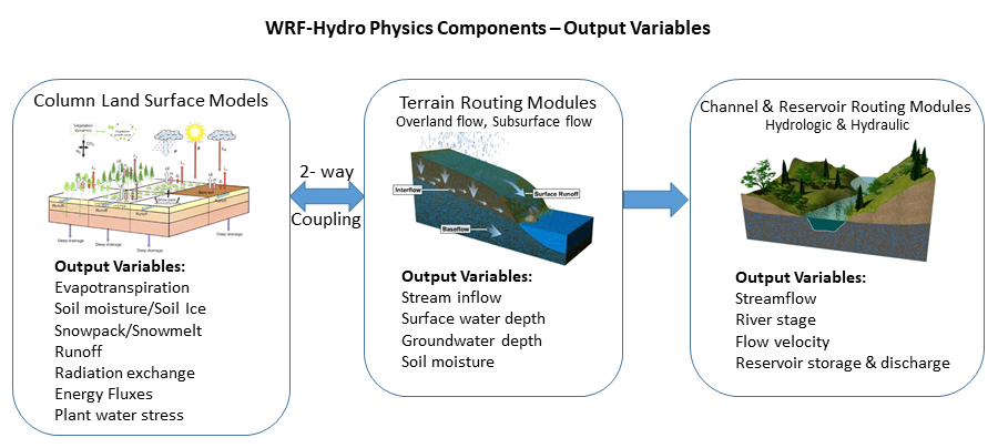
The WRF-Hydro modeling system was originally designed as a model coupling framework to facilitate easier coupling between the Weather Research and Forecasting model and components of terrestrial hydrological models. WRF-Hydro is both a stand-alone hydrological modeling architecture as well as a coupling architecture for coupling of hydrological models with atmospheric models. WRF-Hydro is fully-parallelized to enable its usage on clusters and high performance computing systems alike.
Like the WRF model it does not attempt to prescribe a particular or singular suite of physics but, instead, is designed to be extensible to new hydrological parameterizations. Although it was originally designed to be used within the WRF model, it has evolved over time to possess many additional attributes as follows:
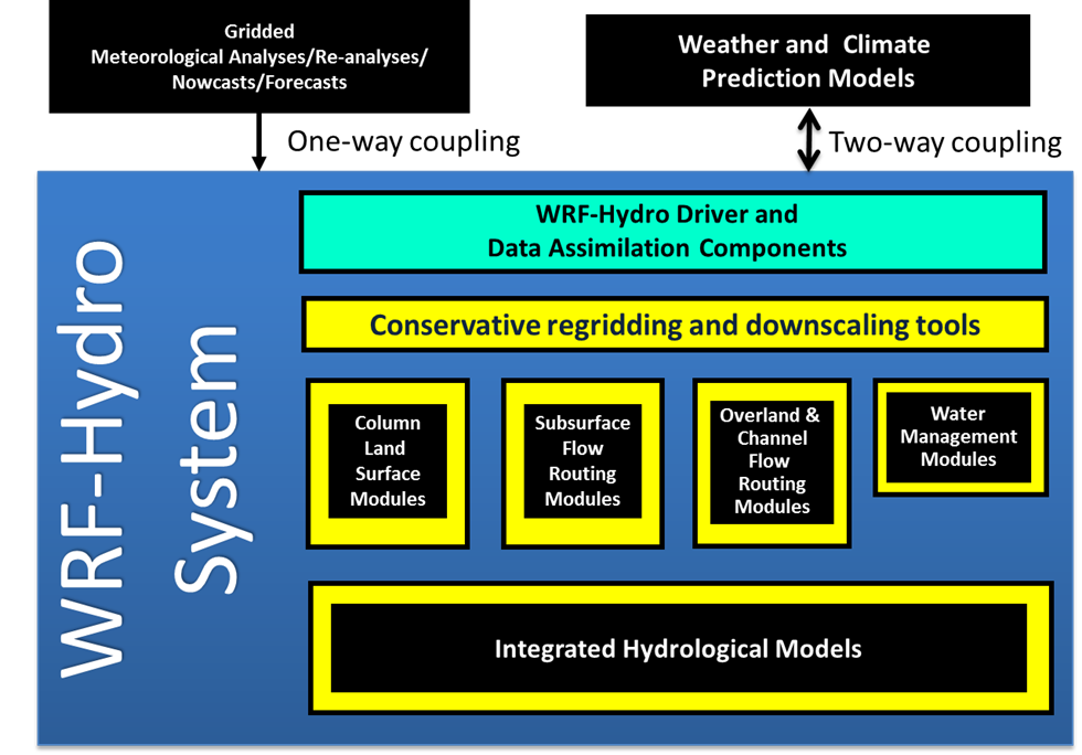
- Multi-scale functionality to permit modeling of atmospheric, land surface and hydrological processes on different spatial grids
- Modularized component model coupling interfaces for many typical terrestrial hydrological processes such as surface runoff, channel flow, lake/reservoir flow, sub-surface flow, land-atmosphere exchanges
- Parallel code development for application on commodity cluster and higher performance computing systems
- Stand-alone capabilities for hydrological prediction and research uncoupled to atmospheric models
- Efficient coupling architecture so that it can be embedded within (or coupled to) other types of Earth system models such as the NCAR Community Earth System Model (CESM) or the NASA Land Information System (LIS)
- Utilization of many standard data formats for efficient job construction and evaluation
- Pre-/post-processing workflows
The architecture is intended to significantly simplify the often laborious task of integrating, or coupling, existing and emerging hydrological models into the WRF modeling framework. In doing so, an extensible, portable and scalable environment for hypothesis testing, sensitivity analysis, data assimilation and environmental prediction has emerged.
The WRF-Hydro system has adopted a ‘community-based’ development processes with an open and participatory working group environment. NCAR in collaboration with other NSF and university entities are developing a support structure for WRF-Hydro in the way of model documentation, public, online code repositories, test cases and many pre- and post-processing utilities.
Applications
The WRF-Hydro system has been applied for a wide range of research and operational prediction problems both in the U.S. and abroad. Specific past projects include flash flood prediction, regional hydroclimate impacts assessment, seasonal forecasting of water resources and land-atmosphere coupling studies. An important aspect of WRF-Hydro system has been serving as the core model for the new National Water Model.
This animation depicts the discharge (cfs) output from the operational National Water Model (v1.2) for the month of April 2019
The WRF-Hydro modeling system has been developed by the National Center for Atmospheric Research and its research partners through the generous support of the U.S. National Science Foundation and through research projects supported by the U.S. National Aeronautics and Space Administration (NASA) and the U.S. National Oceanic and Atmospheric Administration (NOAA).
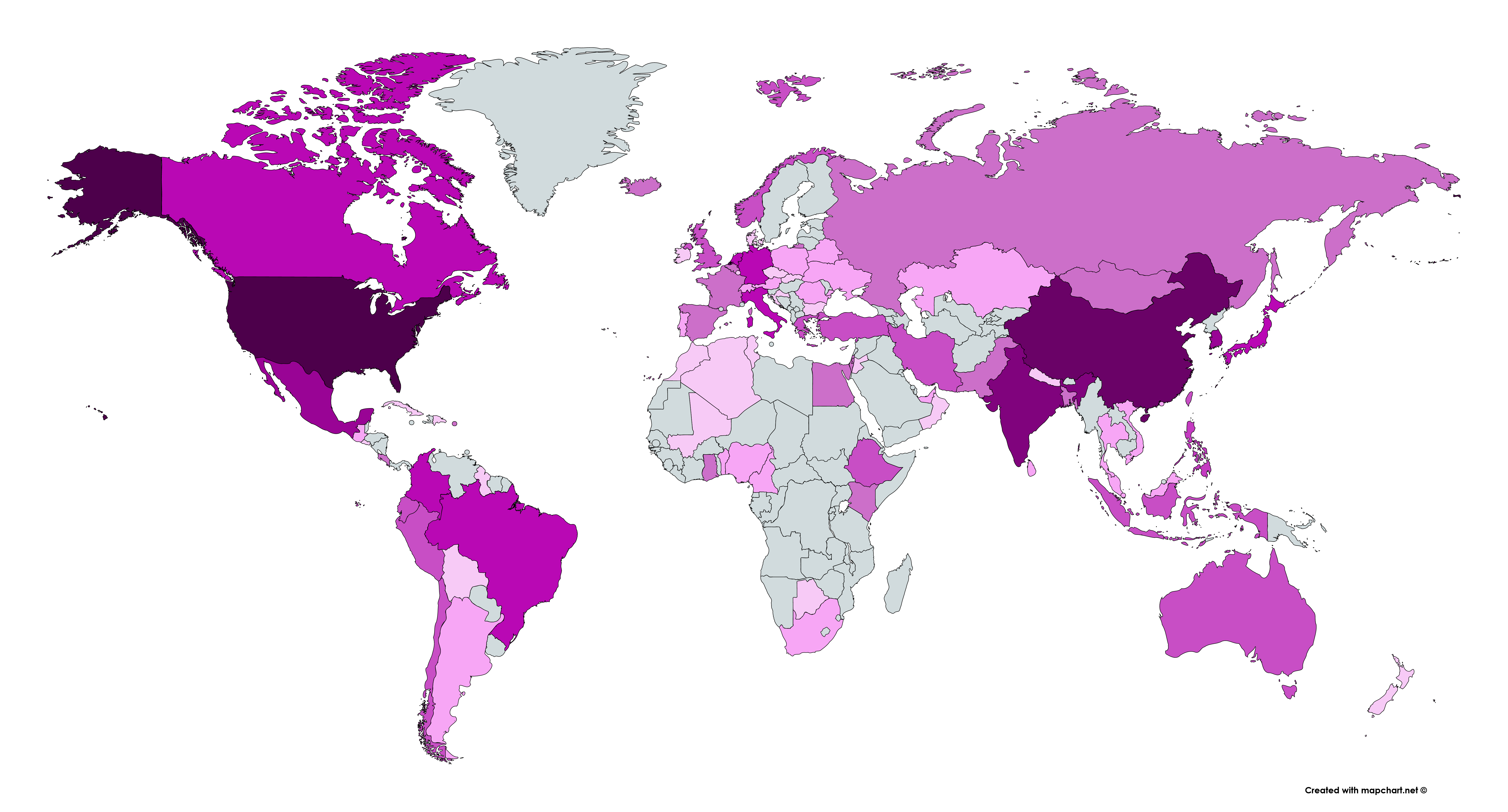
Applications World Wide
Usage by Country of WRF-Hydro® Online Resources
Applications & Collaborations Around the World
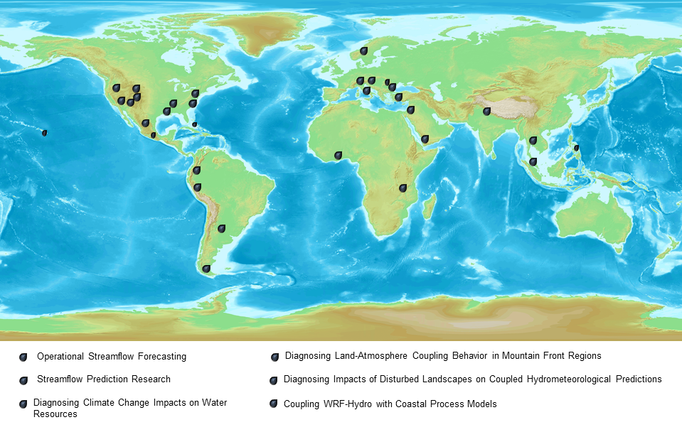
Operational Streamflow Forecasting
- U.S. National Weather Service National Water Model (NOAA/NWS, National Water Center, USGS, CUAHSI)
- Israel National Forecasting System (Israeli Hydrological Service)
- State of Colorado Upper Rio Grande River Basin Water Supply Forecasting (Colorado Water Conservation Board, NOAA/NSSL)
- NCAR-STEP Hydrometeorological Prediction; Colorado Front Range and central Argentina (NCAR)
- Italy reservoir inflow forecasting (Univ. of Calabria)
- Romania National Forecasting System (Baron)
Streamflow Prediction Research
- Flash flooding in Black Sea region of Turkey (Univ. of Ankara)
- Runoff production mechanisms in the North American Monsoon; Northwest Mexico (Arizona State Univ.)
- Streamflow processes in West Africa; Nigeria, (Karlsruhe Inst. Tech.)
Diagnosing Climate Change Impacts on Water Resources
- Himalayan Mountain Front (Bierknes Inst.)
- Colorado Headwaters (Univ. of Colorado)
- U.S. Bureau of Reclamation Dam Safety Group; across the western U.S. (USBR, NOAA/CIRES)
- Lake Tanganyika, Malawi, Water Supply (World Bank)
- Climate change impacts on water resources in Patagonia, Chile (University of La Frontera)
Coupled Land-Atmosphere Processes
- Diagnosing land-atmosphere coupling behavior in mountain-front regions of the U.S. (central and southern Rocky Mountains) and Mexico (Arizona State Univ., Univ. of Arizona)
- Quantifying the impacts of winter orographic cloud seeding on water resources (Wyoming Board on Water Resources)
- Predicting weather and flooding in the Philippines, Luzon Region (USAID, PAGASA, AECOM)
- RELAMPAGO in Argentina (Univ. of Illinois Urbana-Champaign, NCAR)
Coupling WRF-Hydro with Coastal Process Models
- Italy-Adriatic sea interactions (Univ. of Bologna)
- Lower Mississippi River Valley (Louisiana State University)
- Integrated hydrological modeling system for high-resolution coastal applications; U.S. Gulf Coast (U.S. Navy, NOAA, NASA)
Diagnosing the Impacts of Disturbed Landscapes on Coupled Hydro-meteorological Predictions
- Western U.S. Fires (USGS)
- West African Monsoon (Karlsruhe Inst. Tech)
- S. America Parana River (Univ. of Arizona)
- Texas Dust Emissions (Texas A&M Univ.)
- Landslide Hazard Modeling; Colorado Front Range (USGS)
Hydrologic Data Assimilation:
- MODIS snow remote sensing assimilation for water supply prediction in the Western U.S. (Univ. of Colorado, Univ. of California Santa Barbara, NSIDC, NCAR)
- WRF-Hydro/DART application in La Sierra River basins in southeast Mexico (Autonomous National University of Mexico)